Cumbria sits pretty on the top of England. Its beauty is timeless, one that inspired the words from Wordsworth’s quill, and enticed ‘the Lakeland Poets’, Coleridge, Ruskin, Keats and Shelley to stay in this place of lakes, riverside woodland and high fell. If you’re looking for a place to walk, where better than here, and if you’re looking for long distance walk that you can do in a week, look no further than the Cumbria Way.
At just over 72 miles long the Cumbria Way allows you time to walk, also time to look around and be inspired by these great landscapes too. It takes in all that is best in the Lake District; views of the majestic fells, lakeshore promenades and strolls through woodland, past waterfalls, pretty cottages and fine inns. Devised by local Ramblers’ Association groups during the 1970s, the route starts in Ulverston not far from the shores of Morecambe Bay and finishes in the City of Carlisle.
The official way is a low-level walk though the valleys of Cumbria. It’s ideal for both youth hostellers and those liking a bit of luxury. The latter group can ease through leafy Cumbria in style and dine in some of the country inns for which the Lake District is famous. This is not to say backpackers are not catered for: they are, for there are plenty of good campsites throughout the journey.
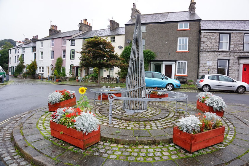
Ulverston is a place unknown to most but you’ll feel its friendly ambiance and laid back style straight away. This is a place of festivals – enjoyment and entertainment is high on the agenda. Strolling around you’ll come across the statues of Laurel and Hardy, Georgian houses and shops and little ginnels threading between the main streets. One of them, Bolton’s Place, has a colourful 70-foot mural painted by the townsfolk and the schoolchildren. If you have time, perhaps you’re staying the night, you may want to visit the canal, climb to see the Sir John Barrow Monument on Hoad Hill and take in a Morecambe Bay sunset from the end of the town’s short canal.
The walk out of Ulverston starts well, on a little beckside path, and more often than not the continuing route is pretty. However there are lots of field paths to negotiate and it’s ‘bitty’. By the time you get to Gawthwaite you’ll feel you won’t make it to Coniston. But you will. The second half of the day seems to go quicker than the first and the paths get easier to follow and enhanced by glimpses of the Coniston Fells peeping above low hills and moors on the horizon.
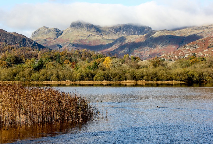
The Lake District proper starts small, with Beacon Tarn, a lake in miniature, surrounded by small but rocky and perfectly formed hills. And those Coniston Fells get nearer and nearer, their rock faces more and more defined. Towards the end of the day you’re strolling on easy paths by Coniston Water, staring across at Ruskin’s Brantwood mansion and contemplating Wordsworth’s daffodils – well okay if it’s too late in the year you can buy the postcard.
The next day the Cumbria Way goes into the heart of the Lake District, taking in more tarns, waterfalls in the woods and whitewashed cottages with rose gardens. It enters Great Langdale, where the rocks form great buttresses and gullies and the mountains become distinctive and gob-smackingly inviting temples. Beneath these temples is the Old Dungeon Ghyll Hotel, a fine place to stop, eat and discuss tomorrow’s route with fellow travellers.
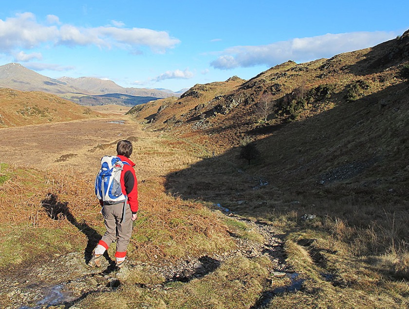
You look to the skies for next day’s route and there’s no obvious way out. The map shows you that the way out is up, over the 500m Stake Pass. It’s steep but short-lived and the path is easy to follow. Next you contemplate Langstrath, a wild, uninhabited valley with nothing but a bouldery river and bouldery mountainsides for comfort. It’s a long way to Keswick from Langdale, maybe too long, so when the walker sees beautiful, ever-so-green and lush Borrowdale he or she may feel the urge to make this an overnight stop. And it would be a good decision for Rosthwaite and Grange are pleasantly peaceful places among beautiful mountain and riverscapes.
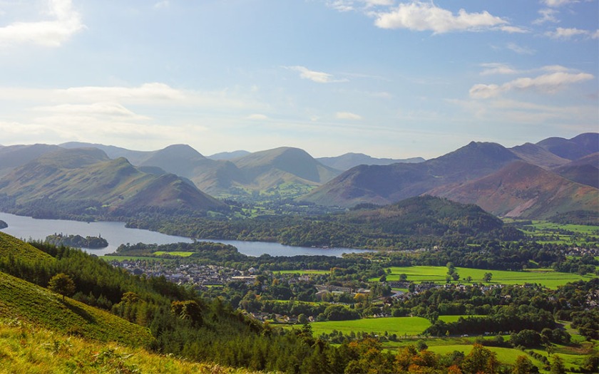
Derwent Water is a prince among the Lake District lakes and that view of Skiddaw’s smooth pastel pink and green shaded slopes is exquisite. Keswick at its north end is lively, a place to restock, maybe recover before the long day over the Back o’ Skidda to Caldbeck. Those who stopped at Rosthwaite are lucky as long as they’ve pre-booked the hostel at Skiddaw House, for they will find they’ve discovered one of the most remote and romantic locations en route and they will have shortened the next day to Caldbeck.
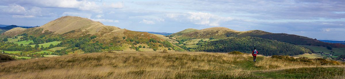
As long as you’re confident enough about the weather to ignore the inferior foul weather Bassenthwaite route, the day out of Keswick will be highlighted by reaching the summit of High Pike, highest place on the whole of the official Cumbria Way at over two thousand feet. It’s an airy place with a view indicator to show you the hundreds of hills in view, including the Scottish ones across the Solway Firth.
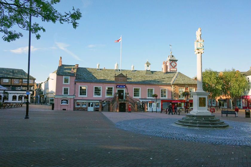
Looking north you can see that there are no more big hills left in England. Between you and your destination there are low ridges and mile upon mile of pastureland. All is not lost though, for the last day will be remembered for its riverside scenery. The Caldew, which you first saw near Skiddaw House, will guide you all the way, including through the streets of Carlisle. And Carlisle’s cathedral quarter is rich in the histories of both England and Scotland. It’s a fitting end to a truly memorable walk.
If all this is not exciting enough for you, what about taking in some mountains?
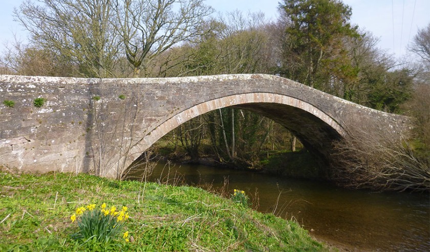
If all this is not exciting enough for you, what about taking in some mountains? The mountain routes come down to meet the official route at convenient points, allowing you to mix and match according to the weather and your inclination or mood. The Cumbria Way passes beneath the Coniston Range but by leaving it a Torver the mountain route takes in Goat’s, Water Swirl How and Great Carrs. It descends to Slater’s Bridge, one of the prettiest ancient packhorse bridges in Cumbria before rejoining the ‘Way’ at Elterwater in Great Langdale.
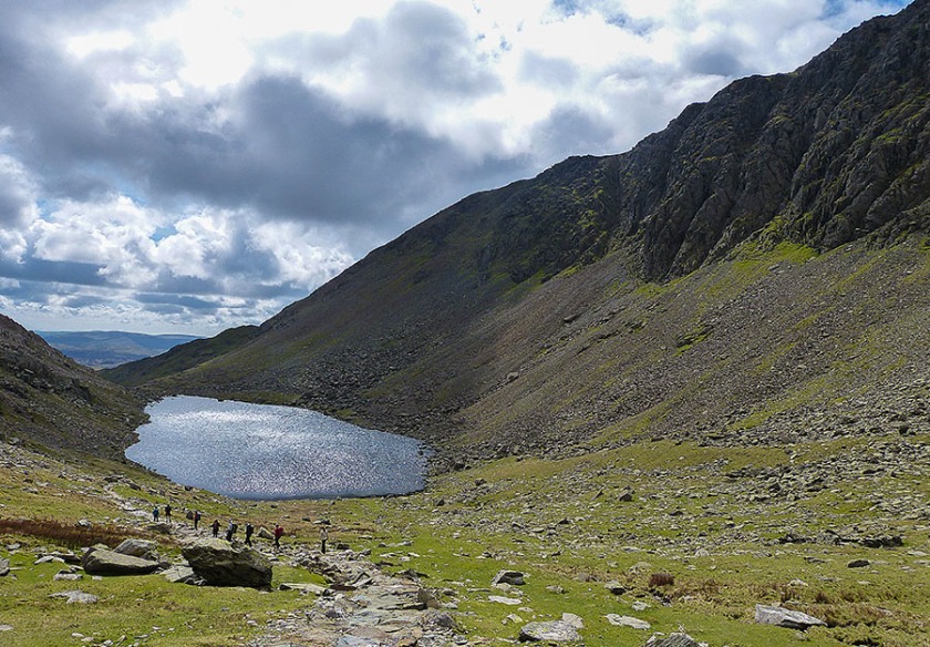
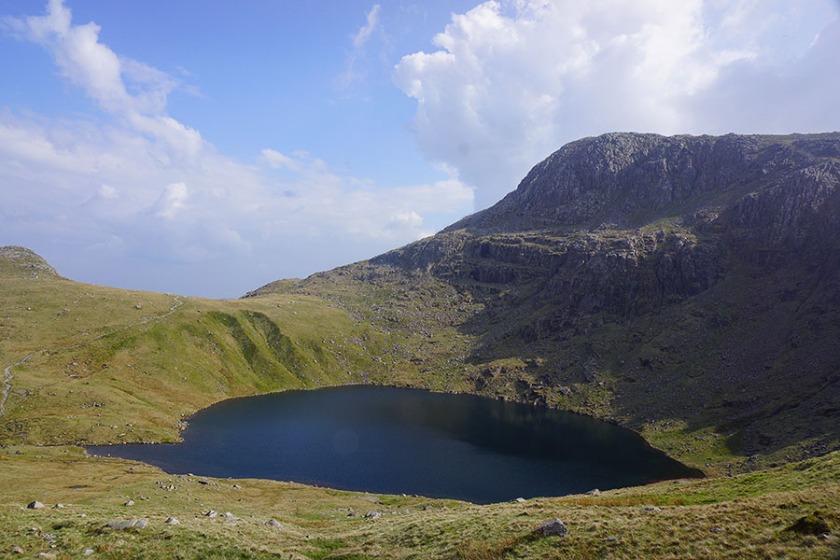
The moraine scenery of the Stake Pass above Great Langdale is fascinating but climbing beneath the buttresses of Bowfell, past Angle Tarn and onto the high peaks of Allen Crags and Glaramara is more spectacular. The way views of Borrowdale open up on the descent from Thornythwaite Fell makes the day worthwhile on its own. Walla Crag comes next. It’s not big but it’s got a well-sculpted rock and heather top with superb views of Derwent Water, Bassenthwaite Lake and the surrounding Fells.
The big one is Skiddaw, one of the Lake District’s three thousand footers. If the day is a fine one Skiddaw is so close that you’ve got to do it. If the day is too big you can drop down from the summit to the hostel at Skiddaw House. Either way, Great Calva, the Knott and High Pike can be included in a high-level traverse to Caldbeck.
Cumbria runs out of mountains beyond Caldbeck so the now-hardened mountain walker can take it easy and follow the official route by the Caldew into Carlisle, knowing that they have completed the ‘Cumbria Mountain Way’.
Wildlife
Once much of Cumbria would have been covered by oak woodland but today’s mosaic of diverse landscapes has been shaped by widespread farming and grazing by deer and sheep. Sheep and cow pastures form a large part of the early Cumbria Way landscape between Ulverston and Gawthorpe and although you’ll see some wildflowers the continuous grazing means species are limited. The thin acid soils of the Coniston foothills mean that bracken, rushes and cotton grass proliferate with the odd birch tree and juniper bushes scattered across the fellsides. In the marshy areas by Beacon Tarn you’ll also see a Bog Myrtle a deciduous shrub about a metre tall with oval leaves. Its oils are claimed to repel biting insects. Although they’re quite common in the dry moors and mountains of the Lake District you’ll probably not see any adders. If you are lucky enough to see one basking on a rock, leave it be for it will almost certainly slither away into the undergrowth when it knows of your presence.
As the path makes its way through mountain valleys you’ll see ravens and buzzards soaring on thermals around the crags above, searching for carrion. The sheep are still here in the low fell country so the main colour will be provided by the larger ‘less tasty’ flowers like the bright yellow gorse and the purple-pink foxgloves. Primroses, bluebells, wood anemone wood sorrel, herb Robert and red campion, will be confined to woodland and hedgerow.
Many of the modern forests are of spruce, pine and larch, although the old coppiced woodland still covers the central regions of the park, especially so between Coniston and Langdale and in Borrowdale. The high rainfall in the sessile oakwoods of Borrowdale has helped propagate lichens, liverworts and insects, which in turn have offered a habitat for various owls, peregrine falcons, pied flycatchers and greater spotted woodpeckers. In the rivers and streams there are otters and you may well see the dipper, a small active dark brown white-chested bird that bobs and dives into the waters looking for insects. I’ve seen grey herons on the River Derwent near Grange. These large long necked wading birds wait, ever so still and patient, for an unsuspecting fish to pass by.
Although it’s in serious decline in southern Britain the shy red squirrel still thrives in the woods of central Cumbria. Elsewhere it has been displaced by the larger grey squirrel, which was introduced from North America.
As the Way approaches Derwent Water’s flood plains you’ll be able to see more Bog Myrtle, also Alder woodland and reed beds, which are ideal for wildfowl and wading birds, including sandpipers. Beneath the waters of the lake is a rare fish, the vendace, which only exists in four British lakes.
In the 1990s ospreys were seen feeding in Bassenthwaite Lake. They had been absent from Cumbria for over 150 years and the Lake District Osprey Project was set up to encourage them to nest here. A nesting platform was erected in woodland above the lake. In 2001 the project’s efforts bore fruit and a chick successfully fledged, the first of many. If you have any time to spare there are viewing platforms in Dodds Wood off the A591 west of Keswick.
The Skiddaw and Back a’ Skidda peaks have thin soils and very few plant species other than expansive carpets of heather, a perfect habitat for the red grouse and the insect-eating sundew.
When to Go
April and May are best for wildflowers and vivid colours – the bracken is still red and contrasts beautifully with the fresh green leaves of the forests. The days are still short but, if you’re a photographer, the sun creates a much better light with pleasing shadows to give depth to your pictures. Also, the campsites and B&Bs won’t be at full capacity and will be more reasonably priced. Summer is obviously warmer, meaning you’ll need less clothing in your rucksack, and the long days give you more time to get to your destination. There would be more time to see the attractions on the way. Autumn is still good, with with the woods, and there are lots of them on the route, displaying beautiful fiery colours. Often the British weather is quite settled at this time. Winter days are short so you’d need to break down the route into more sections and you’d need to pack far more clothes and equipment. Snow and ice would add to the difficulties, especially on the crossing of Stake Pass between Langdale and Borrowdale and the Back o’ Skidda. Most of the campsites, youth hostels and small B&Bs will be closed at this time.
Maps
The OS 1:25,000 Explorer maps needed for the route:
OL6 (Ulverston to Coniston)
OL7 (Coniston to Great Langdale)
OL4 (Great Langdale to Skiddaw House)
OL5 (Skiddaw House to Dalston)
315 (Dalston to Carlisle)
Harvey Maps do a special Cumbria Way 1:40,000 map, which is convenient because everything is on one water-resistant map and it also includes useful town plans
The Book
‘The Cumbria Way’ by John Gillham (Cicerone) ISBN 978-1852847609
Update Notes
The floods of December 2015 caused two landslips in Dentonside Woods east of Caldbeck (at NY 351 403 & NY 355 404). Cumbria County Council has issued a closure notice However in July 2016 the Ramblers Association reported that this section could be walked with care. Check the Ramblers Association site for further updates.
A few miles north the same floods also resulted in Bell Bridge being washed away. Work begins this summer (2017) to rebuild the bridge. Until then follow the short stretch of lane between Sebergham and the west side of the bridge.
Here’s my 15-minute video of the Cumbria Way:

These are some great shots!
LikeLike
Thank you
LikeLike